


 Idea #787 – Watching Antwerp’s old canals under the cobblestones
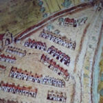
The city of Antwerp was originally built on low hills, crossed by canals. These first served as defense ditches, then, as the city grew, became means of communication. At the end of the Middle Ages, Antwerp was a veritable “city of water”, with the canals of the Ruien, the ditches of the fortifications, Lake Meir and the Scheldt. The Ruien was used as an open sewer by the inhabitants. For hygienic purposes, the city of Antwerp therefore encouraged the construction of buildings above the canals as early as the 16th century, offering the land to those who would cover the canals. A number of important buildings were also built on the ruins, including the Church of Saint-Carole Borromée.
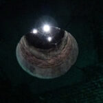
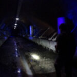
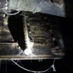
It was not until the end of the 19th century that the canals were completely covered. In the 20th century, the used water system was replaced by pipes, and the ruien was then used only to evacuate rainwater when the rains were too heavy. The Antwerp Canals still today form an 8 kilometer system of underground urban canals in the city of Antwerp. The ruins are partly accessible for organized walking tours, starting from the Ruihuis on the Suikerrui near the Grote Markt.

Some Pictures
Where is it ?
Anvers, Belgium


