


 Idea #596 – Exploring the fossilized island of Schokland in Netherlands
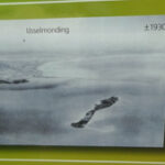
![]() The former island of Schokland was a continental territory busy with the Mesolithic, towards 10 000 B.C. The site is a testimony of the semi-lakeside life, led by the inhabitants of the region during several millenniums. In the course of the centuries, the sea moved forward strongly, winning on lands, until isolate a part of the territory in the form of an island, itself submitted to the assaults of streams always stronger and more powerful.
The former island of Schokland was a continental territory busy with the Mesolithic, towards 10 000 B.C. The site is a testimony of the semi-lakeside life, led by the inhabitants of the region during several millenniums. In the course of the centuries, the sea moved forward strongly, winning on lands, until isolate a part of the territory in the form of an island, itself submitted to the assaults of streams always stronger and more powerful.
From the Middle Ages, terps – or mounds – were raised to allow the installation of housing environments, protected by dikes, trenches and fences. But the rise of the water level was very dangerous for the remaining villages; in 1859, the threat of the floods was so high that the authorities decided to evacuate the islands. In the XXth century, the gulf of Zuiderzee was dried up by the implementation of dikes, and the island Schokland ws enclosed in the continental space, losing its status of island. However, its irregular shape is still visible, in the middle of fields cut according to a systematic grid.
The wealth of its history connected to the sea, and the presence of numerous archeological sites – like neolithic footprints – allowed Schokland to benefit from a registration, in 1995, on the UNESCO world heritage list.

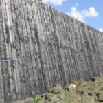
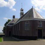
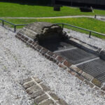
Some Pictures
Where is it ?
Schokland, Netherlands


